
Google Earth Engine ——数据全解析专辑(COPERNICUS/S1_GRD)20154至今哨兵-1号合成孔径雷达 (SAR) 数据集
The Sentinel-1 mission provides data from a dual-polarization C-band Synthetic Aperture Radar (SAR) instrument at 5.405GHz (C band). This collection includes the S1 Ground Range Detected (GRD) scenes....

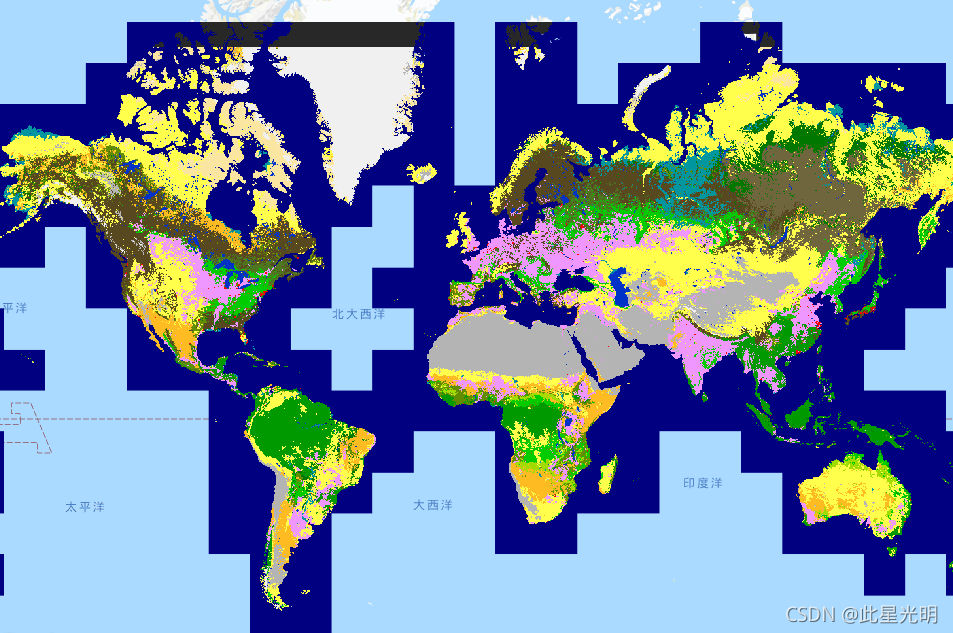
Google Earth Engine ——数据全解析专辑(COPERNICUS/Landcover/100m/Proba-V-C3/Global)2015-2019 年全球土地分类数据集
Copernicus Global Land Cover Layers: CGLS-LC100 Collection 3The Copernicus Global Land Service (CGLS) is earmarked as a component of the Land service to operate a multi-purpose service component that....
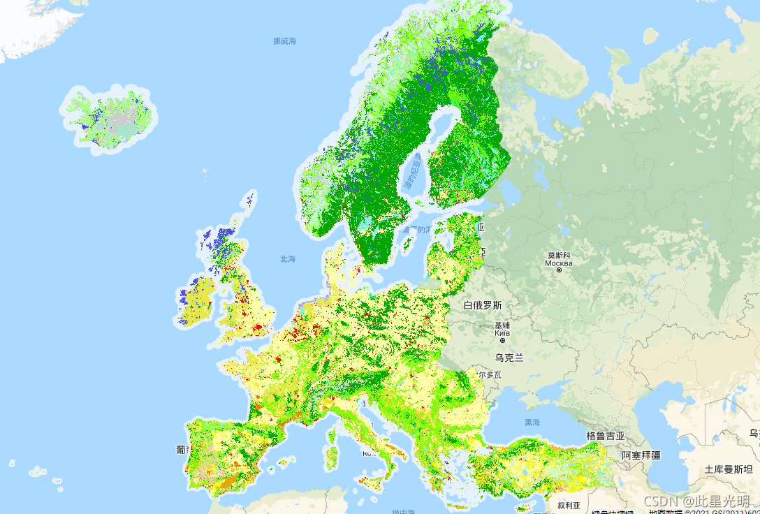
Google Earth Engine ——数据全解析专辑(COPERNICUS/CORINE/V20/100m)欧洲土地利用数据集1986-2018
The CORINE (coordination of information on the environment) Land Cover (CLC) inventory was initiated in 1985 to standardize data collection on land in Europe to support environmental policy developme....
Google Earth Engine ——数据全解析专辑(COPERNICUS/CORINE/V18_5_1/100m)欧洲土地利用数据1986-2012
The CORINE (coordination of information on the environment) Land Cover (CLC) inventory was initiated in 1985 to standardize data collection on land in Europe to support environmental policy developme....

Google Earth Engine ——数据全解析专辑(世界第 4 版网格化人口 (GPWv4) 修订版30 弧秒1公里格网)世界无人区数据集
The Gridded Population of World Version 4 (GPWv4) models the distribution of global human population for the years 2000, 2005, 2010, 2015, and 2020 on 30 arc-second (approximately 1km) grid cells. Po....

Google Earth Engine ——数据全解析专辑(COPERNICUS/S2_SR)20154至今哨兵-2号(SR) 数据集
Sentinel-2 is a wide-swath, high-resolution, multi-spectral imaging mission supporting Copernicus Land Monitoring studies, including the monitoring of vegetation, soil and water cover, as well as obs....

Google Earth Engine ——数据全解析专辑(COPERNICUS/S3/OLCI)20154至今哨兵-3号 数据集
The Ocean and Land Color Instrument (OLCI) Earth Observation Full Resolution (EFR) dataset contains top of atmosphere radiances at 21 spectral bands with center wavelengths ranging between 0.4μm and ....

Google Earth Engine ——Hyperion高分辨率的高光谱(200个波段)数据集
Hyperion is a high resolution hyperspectral imager producing 220 unique spectral channels ranging from 0.357 to 2.576 micrometers with a 10-nm bandwidth. The instrument operates in a pushbroom fashio....

Google Earth Engine ——数据全解析专辑(COPERNICUS/S5P/NRTI/L3_CLOUD)云参数实时高分辨率数据集
NRTI/L3_CLOUD This dataset provides near real-time high-resolution imagery of cloud parameters.The TROPOMI/S5P cloud properties retrieval is based on the OCRA and ROCINN algorithms currently bei....

Google Earth Engine ——美国环境保护署 (USEPA) Ecoregions (地质、地貌、植被、气候、土壤、土地利用、野生动物和水文)数据集
The U.S. Environmental Protection Agency (USEPA) provides the Ecoregions dataset to serve as a spatial framework for the research, assessment, management, and monitoring of ecosystems and ecosystem c....

本页面内关键词为智能算法引擎基于机器学习所生成,如有任何问题,可在页面下方点击"联系我们"与我们沟通。
google engine相关内容
- google earth engine栅格
- google engine数据
- google earth engine下载
- google engine应用
- google engine模型
- google engine构建
- google engine生物量
- google earth engine遥感
- google engine地上
- google engine雷达数据
- google engine空气
- google earth engine地表温度
- google earth engine gee卫星数据
- google earth engine森林序列
- google engine雷达
- google engine气候数据
- google earth engine导出
- google engine导出
- google engine空间
- google earth engine values
- google engine gee火灾
- google engine组织
- google earth engine gee landsat
- google engine landsat8 ndvi
- google earth engine gee landsat8影像
- google engine ndvi
- google earth engine evi
- google engine特征
- google engine gee特征
- google engine计算
google更多engine相关
- google earth engine lst
- google earth engine地图
- google engine gee案例
- google earth engine地表
- google engine面积
- google earth engine影像
- google earth engine融合
- google engine地球
- google engine gee
- google earth engine gee contain
- google earth engine数据集
- google engine分辨率
- google engine影像
- google engine gee数据集
- google earth engine数据数据集
- google engine modis
- google earth engine图像
- google earth engine指数数据集
- google engine数据集分辨率
- google engine植被
- google engine分辨率数据集
- google earth engine土壤
- google earth engine global
- google engine数据集数据
- google earth engine归一化
- google engine dem
- google earth engine人口
- google engine分类
- google earth engine面积
- google earth engine陆地
google您可能感兴趣
- google区别
- google seo
- google分析
- google抓取
- google search
- google代码
- google视频
- google python
- google架构
- google实战
- google earth
- google数据集
- google gee
- google数据
- google play
- google分辨率
- google chrome
- google应用
- google解析
- google开源
- google搜索
- google影像
- google ai
- google浏览器
- google谷歌
- google网站
- google guava
- google地图
- google landsat
- google工具
