
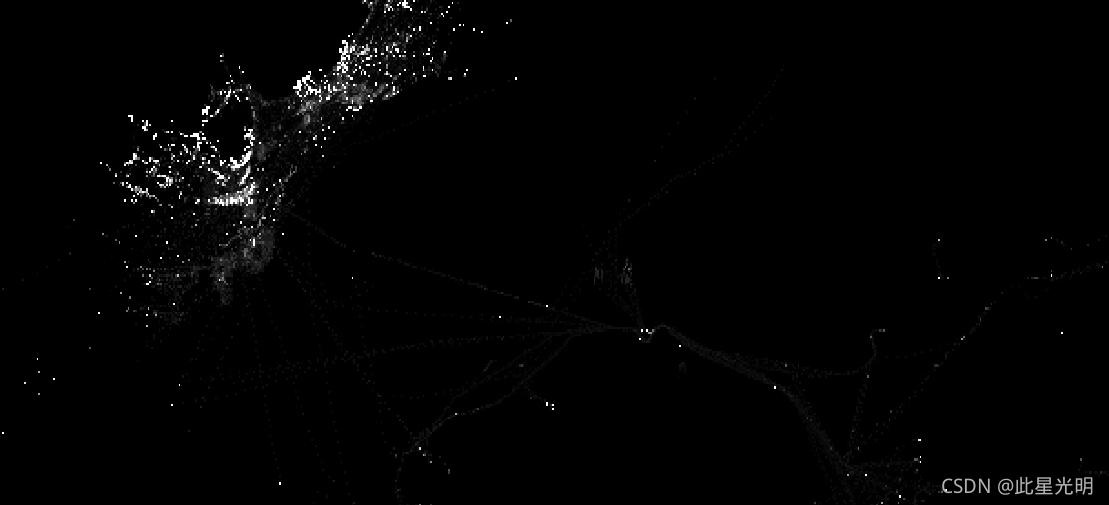
Google Earth Engine ——全球渔船信息GFW/GFF/V1/vessel_hours数据集
Fishing vessel presence, measured in hours per square km. Each asset is the vessel presence for a given flag state and day, with one band for the presence of each gear type.See sample Earth Engine sc....
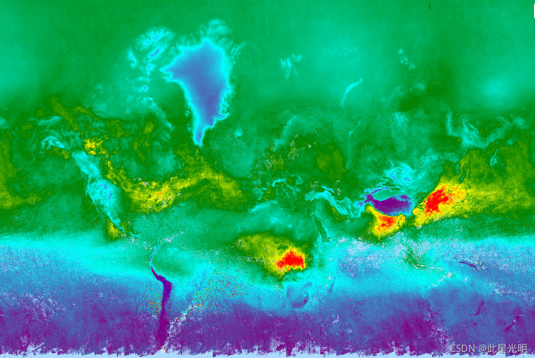
Google Earth Engine ——非洲植被冠层的实际蒸腾量数据集FAO/WAPOR/2/L1_T_D
The transpiration (T) data component (dekadal, in mm/day) is the actual transpiration of the vegetation canopy. The value of each pixel represents the average daily actual transpiration for that spec....

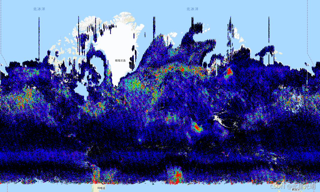
Google Earth Engine ——MODIS Fire_cci焚烧区像素产品5.1版数据集
The MODIS Fire_cci Burned Area pixel product version 5.1 (FireCCI51) is a monthly global ~250m spatial resolution dataset containing information on burned area as well as ancillary data. It is based ....

Google Earth Engine ——数据全解析专辑(COPERNICUS/S5P/NRTI/L3_CO)实时的 CO 浓度高分辨率图像数据集
NRTI/L3_COThis dataset provides near real-time high-resolution imagery of CO concentrations.Carbon monoxide (CO) is an important atmospheric trace gas for understanding tropospheric chemistry. In cer....
Google Earth Engine ——数据全解析专辑(COPERNICUS/S5P/NRTI/L3_AER_AI)紫外线气溶胶指数 (UVAI) 的近实时高分辨率数据集
NRTI/L3_AER_AI This dataset provides near real-time high-resolution imagery of the UV Aerosol Index (UVAI), also called the Absorbing Aerosol Index (AAI).The AAI is based on wavelength-dependent....

Google Earth Engine ——数据全解析专辑(COPERNICUS/S5P/NRTI/L3_NO2) NO2 浓度的离线高分辨率图像数据集
OFFL/L3_NO2 This dataset provides offline high-resolution imagery of NO2 concentrations.Nitrogen oxides (NO2 and NO) are important trace gases in the Earth’s atmosphere, present in both the trop....

Google Earth Engine ——数据全解析专辑(COPERNICUS/S5P/NRTI/L3_O3) O3 浓度的实时高分辨率图像数据集
NRTI/L3_O3This dataset provides near-real-time high-resolution imagery of total column ozone concentrations. See also COPERNICUS/S5P/OFFL/L3_O3_TCL for the tropospheric column data.In the stratospher....

Google Earth Engine ——数据全解析专辑(COPERNICUS/S5P/NRTI/L3_SO2) SO2 浓度的实时高分辨率图像数据集
NRTI/L3_SO2This dataset provides near real-time high-resolution imagery of atmospheric sulfur dioxide (SO2) concentrations.Sulphur dioxide (SO2) enters the Earth’s atmosphere through both natural and....
Google Earth Engine ——数据全解析专辑(COPERNICUS/S5P/OFFL/L3_AER_AI和LH)气溶胶指数数据集
OFFL/L3_AER_AIThis dataset provides offline high-resolution imagery of the UV Aerosol Index (UVAI), also called the Absorbing Aerosol Index (AAI).The AAI is based on wavelength-dependent changes in R....

Google Earth Engine ——数据全解析专辑(Copernicus Global Land Cover Layers: CGLS-LC100 Collec)2015 年全球土地分类数据集
Copernicus Global Land Cover Layers: CGLS-LC100 Collection 2The Copernicus Global Land Service (CGLS) is earmarked as a component of the Land service to operate a multi-purpose service component that....

本页面内关键词为智能算法引擎基于机器学习所生成,如有任何问题,可在页面下方点击"联系我们"与我们沟通。
google engine相关内容
- google earth engine栅格
- google engine数据
- google earth engine下载
- google engine应用
- google engine模型
- google engine构建
- google engine生物量
- google earth engine遥感
- google engine地上
- google engine雷达数据
- google engine空气
- google earth engine地表温度
- google earth engine gee卫星数据
- google earth engine森林序列
- google engine雷达
- google engine气候数据
- google earth engine导出
- google engine导出
- google engine空间
- google earth engine values
- google engine gee火灾
- google engine组织
- google earth engine gee landsat
- google engine landsat8 ndvi
- google earth engine gee landsat8影像
- google engine ndvi
- google earth engine evi
- google engine特征
- google engine gee特征
- google engine计算
google更多engine相关
- google earth engine lst
- google earth engine地图
- google engine gee案例
- google earth engine地表
- google engine面积
- google earth engine影像
- google earth engine融合
- google engine地球
- google engine gee
- google earth engine gee contain
- google earth engine数据集
- google engine分辨率
- google engine影像
- google engine gee数据集
- google earth engine数据数据集
- google engine modis
- google earth engine图像
- google earth engine指数数据集
- google engine数据集分辨率
- google engine植被
- google engine分辨率数据集
- google earth engine土壤
- google earth engine global
- google engine数据集数据
- google earth engine归一化
- google engine dem
- google earth engine人口
- google engine分类
- google earth engine面积
- google earth engine陆地
google您可能感兴趣
- google区别
- google seo
- google分析
- google抓取
- google search
- google代码
- google视频
- google python
- google架构
- google实战
- google earth
- google数据集
- google gee
- google数据
- google play
- google分辨率
- google chrome
- google应用
- google解析
- google开源
- google搜索
- google影像
- google ai
- google浏览器
- google谷歌
- google网站
- google guava
- google地图
- google landsat
- google工具
