
Google Earth Engine ——比Landsat更全的NDVI数据NOAA CDR AVHRR NDVI)1981-2019年0.05 degrees数据集
The NOAA Climate Data Record (CDR) of AVHRR Normalized Difference Vegetation Index (NDVI) contains gridded daily NDVI derived from the NOAA AVHRR Surface Reflectance product. It provides a measuremen....

Google Earth Engine ——LANDSAT/LC08/C01/T1_SR—NDVI数据集
This dataset is the atmospherically corrected surface reflectance from the Landsat 8 OLI/TIRS sensors. These images contain 5 visible and near-infrared (VNIR) bands and 2 short-wave infrared (SWIR) b....

Google Earth Engine ——HYCOM 数据子集包含变量海洋温度数据集
The Hybrid Coordinate Ocean Model (HYCOM) is a data-assimilative hybrid isopycnal-sigma-pressure (generalized) coordinate ocean model. The subset of HYCOM data hosted in EE contains the variables sal....
Google Earth Engine ——数据全解析专辑(全球550纳米表面的总气溶胶0.4 度数据集)
The Copernicus Atmosphere Monitoring Service provides the capacity to continuously monitor the composition of the Earth’s atmosphere at global and regional scales. The main global near-real-time prod....

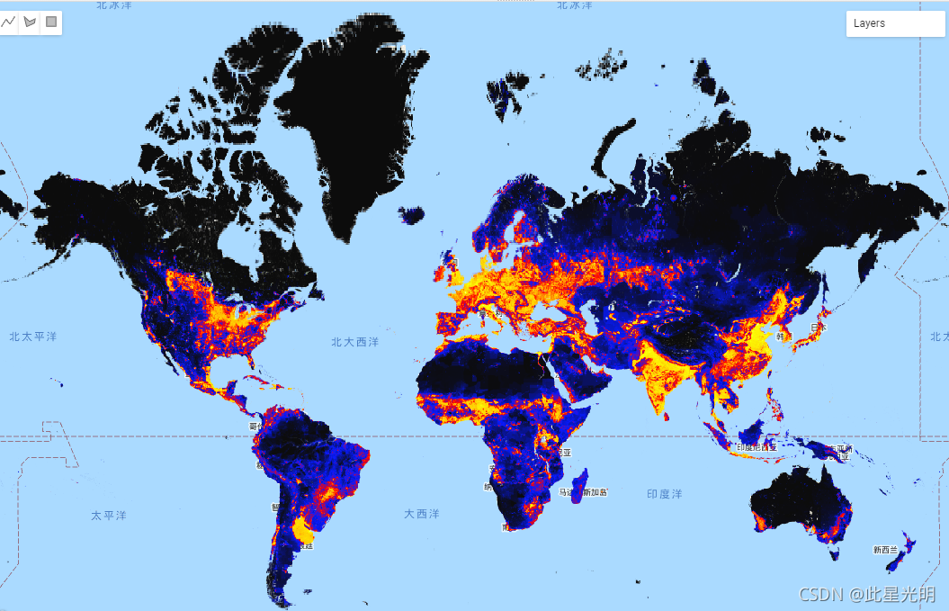
Google Earth Engine ——数据全解析专辑(全球人类改变数据集(gHM)以1千米的分辨率数据集)
The global Human Modification dataset (gHM) provides a cumulative measure of human modification of terrestrial lands globally at 1 square-kilometer resolution. The gHM values range from 0.0-1.0 and a....
Google Earth Engine ——数据全解析专辑(COPERNICUS/S5P/OFFL/L3_HCHO)大气甲醛 (HCHO) 浓度的离线高分辨率数据集
OFFL/L3_HCHO This dataset provides offline high-resolution imagery of atmospheric formaldehyde (HCHO) concentrations.Formaldehyde is an intermediate gas in almost all oxidation chains of non-met....

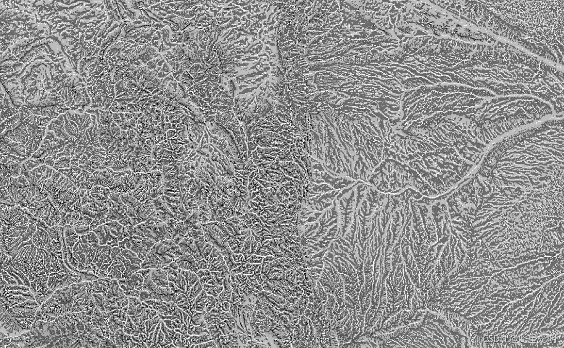
Google Earth Engine ——数据全解析专辑(US NED CHILI /Landforms/Topographic Diversity)美国DEM地形10米分辨率数据集
本次介绍三个数据集: CHILICHILI is a surrogate for effects of insolation and topographic shading on evapotranspiration represented by calculating insolation at early afternoon, sun altitude equivalent to equin....

Google Earth Engine ——数据全解析专辑(US NED mTPI (生态相关地貌(ERGo)270m分辨率数据集)
The mTPI distinguishes ridge from valley forms. It is calculated using elevation data for each location subtracted by the mean elevation within a neighborhood. mTPI uses moving windows of radius (km)....

Google Earth Engine ——数据全解析专辑(US NED Physiographic Diversity地貌多样性数据集)
The Physiographic Diversity dataset provides an index of the diversity of physiographic types. It was calculated using the Shannon diversity index at multiple-scales (km): 115.8, 89.9, 35.5, 13.1, 5.....

Google Earth Engine ——数据全解析专辑(US NED Physiographic Diversity地貌数据集代表地貌和岩性数据集)
The Physiography dataset represents the spatial intersection of landforms (available in EE as ERGo/1_0/US/landforms) and lithology (available in EE as ERGo/1_0/US/lithology) data layers. It provides ....
本页面内关键词为智能算法引擎基于机器学习所生成,如有任何问题,可在页面下方点击"联系我们"与我们沟通。
google engine相关内容
- google earth engine栅格
- google engine数据
- google earth engine下载
- google engine应用
- google engine模型
- google engine构建
- google engine生物量
- google earth engine遥感
- google engine地上
- google engine雷达数据
- google engine空气
- google earth engine地表温度
- google earth engine gee卫星数据
- google earth engine森林序列
- google engine雷达
- google engine气候数据
- google earth engine导出
- google engine导出
- google engine空间
- google earth engine values
- google engine gee火灾
- google engine组织
- google earth engine gee landsat
- google engine landsat8 ndvi
- google earth engine gee landsat8影像
- google engine ndvi
- google earth engine evi
- google engine特征
- google engine gee特征
- google engine计算
google更多engine相关
- google earth engine lst
- google earth engine地图
- google engine gee案例
- google earth engine地表
- google engine面积
- google earth engine影像
- google earth engine融合
- google engine地球
- google engine gee
- google earth engine gee contain
- google earth engine数据集
- google engine分辨率
- google engine影像
- google engine gee数据集
- google earth engine数据数据集
- google engine modis
- google earth engine图像
- google earth engine指数数据集
- google engine数据集分辨率
- google engine植被
- google engine分辨率数据集
- google earth engine土壤
- google earth engine global
- google engine数据集数据
- google earth engine归一化
- google engine dem
- google earth engine人口
- google engine分类
- google earth engine面积
- google earth engine陆地
google您可能感兴趣
- google区别
- google seo
- google分析
- google抓取
- google search
- google代码
- google视频
- google python
- google架构
- google实战
- google earth
- google数据集
- google gee
- google数据
- google play
- google分辨率
- google chrome
- google应用
- google解析
- google开源
- google搜索
- google影像
- google ai
- google浏览器
- google谷歌
- google网站
- google guava
- google地图
- google landsat
- google工具