
Google Earth Engine ——基于MODIS数据集JRC/GWIS/GlobFire/v2/FinalPerimetersMCD64A1的火灾边界数据集
Fire boundaries based on the MODIS dataset MCD64A1. The data were computed based on an algorithm that relies on encoding in a graph structure a space-time relationship among patches of burned areas.&a...

Google Earth Engine ——美国LANDIFRE火灾LANDFIRE FRG (Fire Regime Groups) v1.2.0数据集
LANDFIRE (LF), Landscape Fire and Resource Management Planning Tools, is a shared program between the wildland fire management programs of the U.S. Department of Agriculture's Forest Service, U.S. De....

Google Earth Engine ——美国LANDIFRE火灾数据集LANDFIRE MFRI (Mean Fire Return Interval) v1.2.0数据集内包含多种数据要素
LANDFIRE (LF), Landscape Fire and Resource Management Planning Tools, is a shared program between the wildland fire management programs of the U.S. Department of Agriculture's Forest Service, U.S. De....

Google Earth Engine ——美国LANDIFRE火灾数据集LANDFIRE/Fire/PLS/v1_2_0数据集内包含多种数据要素
LANDFIRE (LF), Landscape Fire and Resource Management Planning Tools, is a shared program between the wildland fire management programs of the U.S. Department of Agriculture's Forest Service, U.S. De....

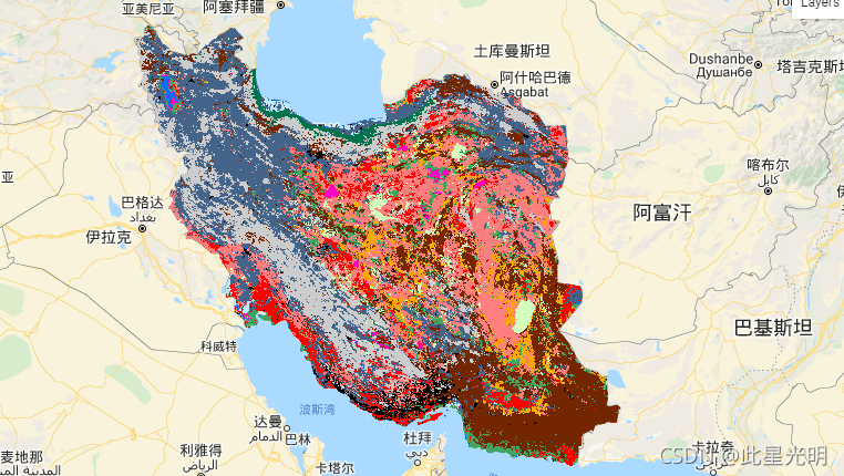
Google Earth Engine ——2017-2018年伊朗土地覆盖/土地利用数据集KNTU/LiDARLab/IranLandCover/V1
The Iran-wide land cover map was generated by processing Sentinel imagery within the Google Earth Engine Cloud platform. For this purpose, over 2,500 Sentinel-1 and over 11,000 Sentinel-2 images were....
Google Earth Engine ——美国LANDIFRE植被数据集包括。生物物理设置(BPS)环境场地潜力(ESP)现有植被冠层(EVC)现有植被高度(EVH)现有植被类型(EVT)数据集
Google Earth Engine ——美国LANDIFRE植被数据集包括。生物物理设置(BPS)环境场地潜力(ESP)现有植被冠层(EVC)现有植被高度(EVH)现有植被类型(EVT)数据集

Google Earth Engine ——欧洲联盟三年一次的原地土地覆盖和土地利用数据(共有106个属性)
The Land Use/Cover Area frame Survey (LUCAS) in the European Union (EU) was set up to provide statistical information. It represents a triennial in-situ landcover and land-use data-collection exercis....

Google Earth Engine ——ALOS World 3D - 30m (AW3D30) 是一个全球数字表面模型 (DSM) 数据集
ALOS World 3D - 30m (AW3D30) is a global digital surface model (DSM) dataset with a horizontal resolution of approximately 30 meters (1 arcsec mesh). The dataset is based on the DSM dataset (5-meter ....

Google Earth Engine ——高级陆地观测卫AVNIR-2 ORI 产品10m分辨率
This dataset is contains orthorectified imagery from the Advanced Visible and Near Infrared Radiometer type 2 (AVNIR-2) sensor on-board the Advanced Land Observing Satellite (ALOS) "DAICHI".The AVNIR....

Google Earth Engine ——2001-2017年非洲土壤在 土壤深度为 0-20 厘米和 20-50 厘米的美国农业部质地等级数据,预测平均值和标准偏差
USDA Texture Class at soil depths of 0-20 cm and 20-50 cm. In areas of dense jungle (generally over central Africa), model accuracy is low and therefore artefacts such as banding (striping) migh....

本页面内关键词为智能算法引擎基于机器学习所生成,如有任何问题,可在页面下方点击"联系我们"与我们沟通。
google engine相关内容
- google earth engine栅格
- google engine数据
- google earth engine下载
- google engine应用
- google engine模型
- google engine构建
- google engine生物量
- google earth engine遥感
- google engine地上
- google engine雷达数据
- google engine空气
- google earth engine地表温度
- google earth engine gee卫星数据
- google earth engine森林序列
- google engine雷达
- google engine气候数据
- google earth engine导出
- google engine导出
- google engine空间
- google earth engine values
- google engine gee火灾
- google engine组织
- google earth engine gee landsat
- google engine landsat8 ndvi
- google earth engine gee landsat8影像
- google engine ndvi
- google earth engine evi
- google engine特征
- google engine gee特征
- google engine计算
google更多engine相关
- google earth engine lst
- google earth engine地图
- google engine gee案例
- google earth engine地表
- google engine面积
- google earth engine影像
- google earth engine融合
- google engine地球
- google engine gee
- google earth engine gee contain
- google earth engine数据集
- google engine分辨率
- google engine影像
- google engine gee数据集
- google earth engine数据数据集
- google engine modis
- google earth engine图像
- google earth engine指数数据集
- google engine数据集分辨率
- google engine植被
- google engine分辨率数据集
- google earth engine土壤
- google earth engine global
- google engine数据集数据
- google earth engine归一化
- google engine dem
- google earth engine人口
- google engine分类
- google earth engine面积
- google earth engine陆地
google您可能感兴趣
- google代码
- google视频
- google python
- google架构
- google实战
- google模型
- google工具
- google搜索功能
- google策略
- google推理
- google earth
- google数据集
- google gee
- google数据
- google play
- google分辨率
- google chrome
- google应用
- google解析
- google开源
- google搜索
- google影像
- google ai
- google浏览器
- google分析
- google谷歌
- google网站
- google guava
- google地图
- google landsat
