
Google Earth Engine——2017简化版本美国地理学家办公室提供大尺度国际边界(LSIB)数据集
LSIB 2017: Large Scale International Boundary Polygons, SimplifiedThe United States Office of the Geographer provides the Large Scale International Boundary (LSIB) dataset. The detailed version (2013....

Google Earth Engine——2017细节版本美国地理学家办公室提供大尺度国际边界(LSIB)数据集。
LSIB 2017: Large Scale International Boundary Polygons, DetailedThe United States Office of the Geographer provides the Large Scale International Boundary (LSIB) dataset. It is derived from two other....

Google Earth Engine——USGS GAP CONUS 2011GAP/LANDFIRE国家陆地生态系统数据代表了美国本土、阿拉斯加、夏威夷和波多黎各的详细植被和土地覆盖分类。
USGS GAP CONUS 2011The GAP/LANDFIRE National Terrestrial Ecosystems data represents a detailed vegetation and land cover classification for the Conterminous U.S., Alaska, Hawaii, and Puerto Rico.GAP/....

Google Earth Engine——USGS GAP Hawaii 2001夏威夷的详细植被和土地覆盖分类
USGS GAP Hawaii 2001The GAP/LANDFIRE National Terrestrial Ecosystems data represents a detailed vegetation and land cover classification for the Conterminous U.S., Alaska, Hawaii, and Puerto Rico.GAP....

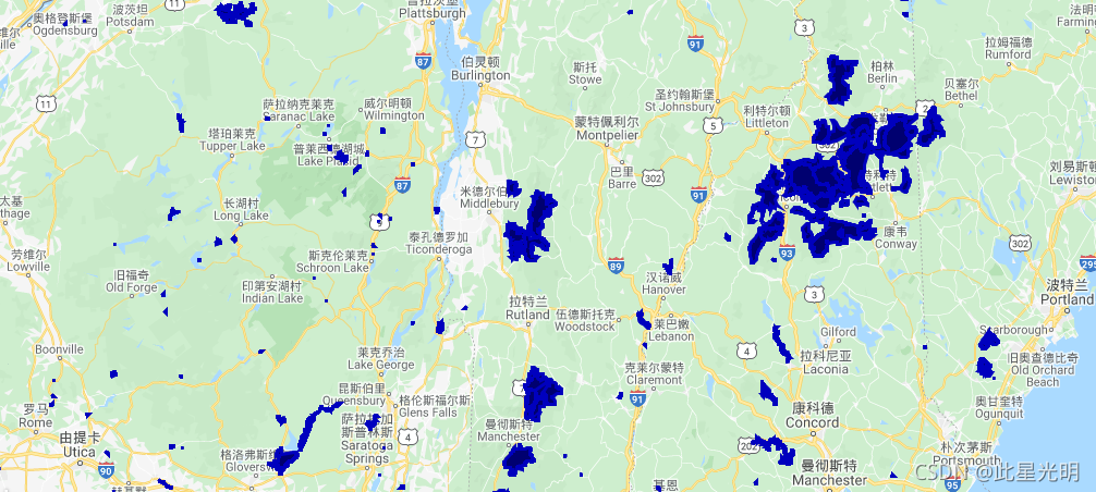
Google Earth Engine——PAD-US是美国官方的国家清单,其中包括专门用于保护生物多样性和其他自然、娱乐和文化用途的美国陆地和海洋保护区,并通过法律或其他有效手段对这些区域进行管理。
PAD-US is America's official national inventory of U.S. terrestrial and marine protected areas that are dedicated to the preservation of biological diversity and to other natural, recreation and cult....
Google Earth Engine——USGS/GAP/PR/2001波多黎各的详细植被和土地覆盖分类
USGS/GAP/PR/2001The GAP/LANDFIRE National Terrestrial Ecosystems data represents a detailed vegetation and land cover classification for the Conterminous U.S., Alaska, Hawaii, and Puerto Rico.GAP/LF ....

Google Earth Engine——世界已公开的人口数据集
整体的代码思路是选择开放的数据集,进行加载,加载的图层分别包括总人口,男人、女人、青少年、5岁以下儿童、产妇以及超过60岁的人的分类,最后加载了全球开放的国家边界数据。代码:var HRSL = ee.ImageCollection("projects/sat-io/open-datasets/hrsl/hrslpop"); var HRSL_men = ee.ImageCollec....

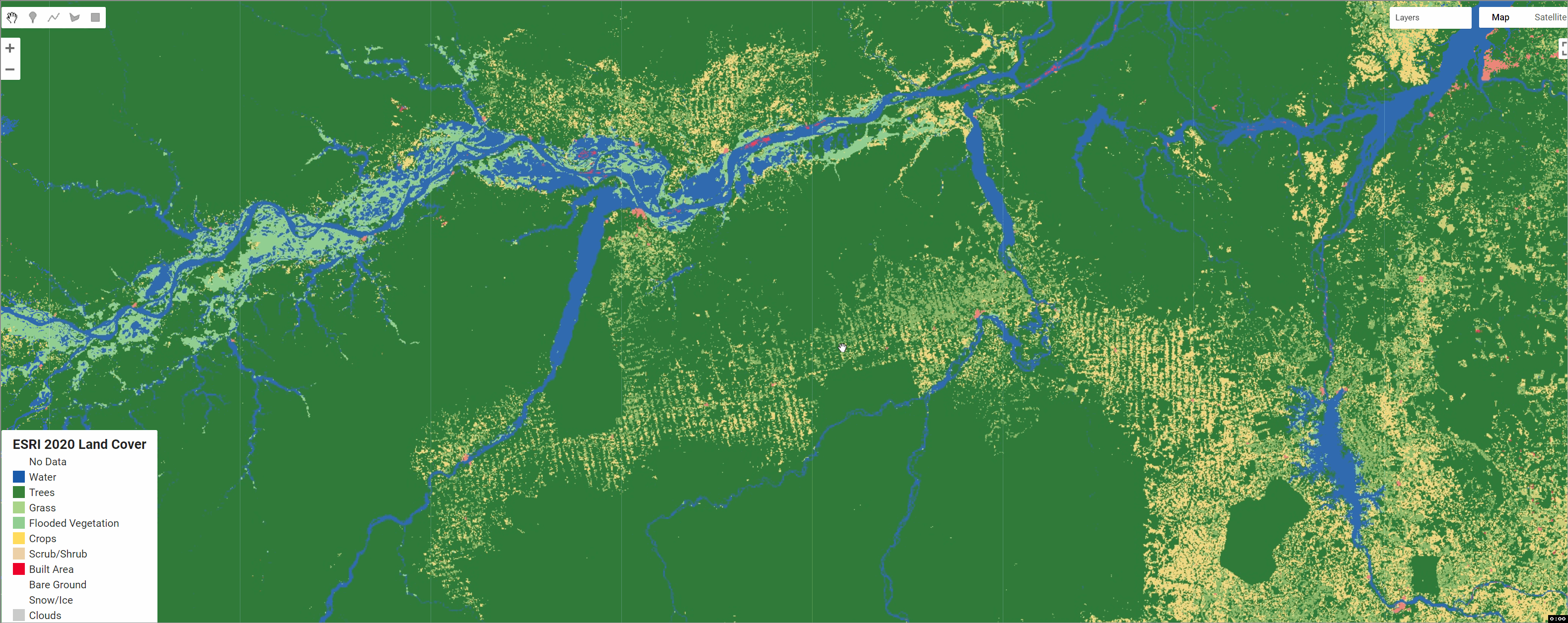
全球土地利用数据ESRI 10m Land Cover 2020 in GEE(Google Earth Engine)
此图层显示土地利用/土地覆盖 (LULC) 的全球地图。该地图来自 ESA Sentinel-2 图像,分辨率为 10m。它综合了全年 10 个类别的 LULC 预测,以生成 2020 年的代表性快照。该地图由深度学习模型生成,该模型使用超过 50 亿个手工标记的 Sentinel-2 像素进行训练,从 20,000 多个站点中采样分布于世界所有主要生物群落。 数据引用:Karra, ....
Google Earth Engine ——MYD10A1 V6 Snow Cover Daily Global 500m产品包含雪盖、雪反照率、雪盖分率和质量评估(QA)数据归一化差异积雪指数数据集
The MYD10A1 V6 Snow Cover Daily Global 500m product contains snow cover, snow albedo, fractional snow cover, and quality assessment (QA) data. Snow cover data are based on a snow mapping algorithm th....

Google Earth Engine ——MYD09Q1.006 Aqua 地表反射率 8-Day Global 250m提供了第1和第2波段的表面光谱反射率的估计,并对气体、气溶胶和瑞利散射等校正
The MYD09Q1 product provides an estimate of the surface spectral reflectance of bands 1 and 2 at 250m resolution and corrected for atmospheric conditions such as gasses, aerosols, and Rayleigh scatte....

本页面内关键词为智能算法引擎基于机器学习所生成,如有任何问题,可在页面下方点击"联系我们"与我们沟通。
google engine相关内容
- google earth engine栅格
- google engine数据
- google earth engine下载
- google engine应用
- google engine模型
- google engine构建
- google engine生物量
- google earth engine遥感
- google engine地上
- google engine雷达数据
- google engine空气
- google earth engine地表温度
- google earth engine gee卫星数据
- google earth engine森林序列
- google engine雷达
- google engine气候数据
- google earth engine导出
- google engine导出
- google engine空间
- google earth engine values
- google engine gee火灾
- google engine组织
- google earth engine gee landsat
- google engine landsat8 ndvi
- google earth engine gee landsat8影像
- google engine ndvi
- google earth engine evi
- google engine特征
- google engine gee特征
- google engine计算
google更多engine相关
- google earth engine lst
- google earth engine地图
- google engine gee案例
- google earth engine地表
- google engine面积
- google earth engine影像
- google earth engine融合
- google engine地球
- google engine gee
- google earth engine gee contain
- google earth engine数据集
- google engine分辨率
- google engine影像
- google engine gee数据集
- google earth engine数据数据集
- google engine modis
- google earth engine图像
- google earth engine指数数据集
- google engine数据集分辨率
- google engine植被
- google engine分辨率数据集
- google earth engine土壤
- google earth engine global
- google engine数据集数据
- google earth engine归一化
- google engine dem
- google earth engine人口
- google engine分类
- google earth engine面积
- google earth engine陆地
google您可能感兴趣
- google区别
- google seo
- google分析
- google抓取
- google search
- google代码
- google视频
- google python
- google架构
- google实战
- google earth
- google数据集
- google gee
- google数据
- google play
- google分辨率
- google chrome
- google应用
- google解析
- google开源
- google搜索
- google影像
- google ai
- google浏览器
- google谷歌
- google网站
- google guava
- google地图
- google landsat
- google工具