
Google Earth Engine——NASA NEX-DCP30数据集(降水和气温)由美国本土的降尺度气候情景组成1km分辨率
The NASA NEX-DCP30 dataset is comprised of downscaled climate scenarios for the conterminous United States that are derived from the General Circulation Model (GCM) runs conducted under the Coupled M....

Google Earth Engine(GEE)——利用sentinel-5P数据进行中国区域so2二氧化硫的2019-2020年差异分析
数据简介: OFFL/L3_SO2This dataset provides offline high-resolution imagery of atmospheric sulfur dioxide (SO2) concentrations.Sulphur dioxide (SO2) enters the Earth’s atmosphere through both natural....
Google Earth Engine——美国人口普查局的TIGER数据集包含美国主要政府部门的2016年边界。除了50个州之外,人口普查局还将哥伦比亚特区、波多黎各和每个岛屿地区
The United States Census Bureau TIGER dataset contains the 2016 boundaries for the primary governmental divisions of the United States. In addition to the fifty states, the Census Bureau treats the D....

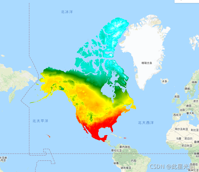
Google Earth Engine——地球科学激光测高系统(GLAS)的空间激光雷达数据(2005年)和辅助地理空间数据融合的全球树木高度数据集
This dataset represents global tree heights based on a fusion of spaceborne-lidar data (2005) from the Geoscience Laser Altimeter System (GLAS) and ancillary geospatial data. See [Simard et al. (2011....

Google Earth Engine(GEE)——哨兵数据中隐藏的秘密(卫星影像拍到的如来神掌)
今天突然看到外网的一个博客中展示的一张图片:本来尝试着用用分辨率较为粗的modis影像查看,但是因为影像分辨率太粗了,所以只能放弃,不错具体加载的图,也在下面:我们再看看Landsat8影像是否抓拍到这个如来神掌: 这里依旧是十分模糊的一个不到几十个像素的,分辨率有限。 看看最终展示的代码://modis var dataset = ee.ImageCollection('MODIS/006/.....

Google Earth Engine——NASA DEM是对STRM数据的再处理,通过纳入ASTER GDEM、ICESat GLAS和PRISM数据集的辅助数据,提高了精度
NASADEM is a reprocessing of STRM data, with improved accuracy by incorporating auxiliary data from ASTER GDEM, ICESat GLAS, and PRISM datasets.The most significant processing improvements involve vo....

Google Earth Engine——美国人口普查局的TIGER数据集包含了2016年发布的所有路段,包含了1900多万条单独的线路特征,覆盖了美国、哥伦比亚特区、波多黎各和岛屿地区
This United States Census Bureau TIGER dataset contains all road segments from the 2016 release, containing more than 19 million individual line features covering the United States, the District of C....

Google Earth Engine——2017年更新的RESOLVE生态区数据集提供了代表我们生活星球的846个陆地生态区的描述数据集
The RESOLVE Ecoregions dataset, updated in 2017, offers a depiction of the 846 terrestrial ecoregions that represent our living planet. View the stylized map at https://ecoregions2017.appspot.com/ or....

Google Earth Engine——海面温度--WHOI数据集是NOAA海洋表面(OSB)的一部分,提供了无冰海洋的高质量的气候数据记录(CDR)
The Sea Surface Temperature - WHOI dataset is part of the NOAA Ocean Surface Bundle (OSB) and provides a high quality Climate Data Record (CDR) of sea surface temperature over ice-free oceans.The SST....

Google Earth Engine——Daymet V3提供美国、墨西哥、加拿大、夏威夷和波多黎各的每日天气参数的网格化气象数据集
Daymet V3 provides gridded estimates of daily weather parameters for United States, Mexico, Canada, Hawaii, and Puerto Rico. It is derived from selected meteorological station data and various suppor....
本页面内关键词为智能算法引擎基于机器学习所生成,如有任何问题,可在页面下方点击"联系我们"与我们沟通。
google engine相关内容
- google earth engine栅格
- google engine数据
- google earth engine下载
- google engine应用
- google engine模型
- google engine构建
- google engine生物量
- google earth engine遥感
- google engine地上
- google engine雷达数据
- google engine空气
- google earth engine地表温度
- google earth engine gee卫星数据
- google earth engine森林序列
- google engine雷达
- google engine气候数据
- google earth engine导出
- google engine导出
- google engine空间
- google earth engine values
- google engine gee火灾
- google engine组织
- google earth engine gee landsat
- google engine landsat8 ndvi
- google earth engine gee landsat8影像
- google engine ndvi
- google earth engine evi
- google engine特征
- google engine gee特征
- google engine计算
google更多engine相关
- google earth engine lst
- google earth engine地图
- google engine gee案例
- google earth engine地表
- google engine面积
- google earth engine影像
- google earth engine融合
- google engine地球
- google engine gee
- google earth engine gee contain
- google earth engine数据集
- google engine分辨率
- google engine影像
- google engine gee数据集
- google earth engine数据数据集
- google engine modis
- google earth engine图像
- google earth engine指数数据集
- google engine数据集分辨率
- google engine植被
- google engine分辨率数据集
- google earth engine土壤
- google earth engine global
- google engine数据集数据
- google earth engine归一化
- google engine dem
- google earth engine人口
- google engine分类
- google earth engine面积
- google earth engine陆地
google您可能感兴趣
- google区别
- google seo
- google分析
- google抓取
- google search
- google代码
- google视频
- google python
- google架构
- google实战
- google earth
- google数据集
- google gee
- google数据
- google play
- google分辨率
- google chrome
- google应用
- google解析
- google开源
- google搜索
- google影像
- google ai
- google浏览器
- google谷歌
- google网站
- google guava
- google地图
- google landsat
- google工具
