
Google Earth Engine——Layer error: Description length exceeds maximum.解决办法
问题: 图片上的问题主要在于imag5.sum().clip(table),另外,如果是imagecollection的话不能直接裁剪,不许经过一系列运算,也就是镶嵌mosaic()或者.first()编程一张影像才可以进行裁剪和reduceRegion()等一些列最大值、最小值、平均值的计算Map.addLayer(eeObject, visParams, name, shown, opaci....

Google Earth Engine——Landsat图像在描述全球森林范围和变化方面的时间序列分析结果(2014年)
Results from time-series analysis of Landsat images in characterizing global forest extent and change.The 'first' and 'last' bands are reference multispectral imagery from the first and last availabl....

Google Earth Engine——国家农业图像计划(NAIP)在美国大陆的农业生长季节获取航空图像,1米分辨率
The National Agriculture Imagery Program (NAIP) acquires aerial imagery during the agricultural growing seasons in the continental U.S.NAIP projects are contracted each year based upon available fund....

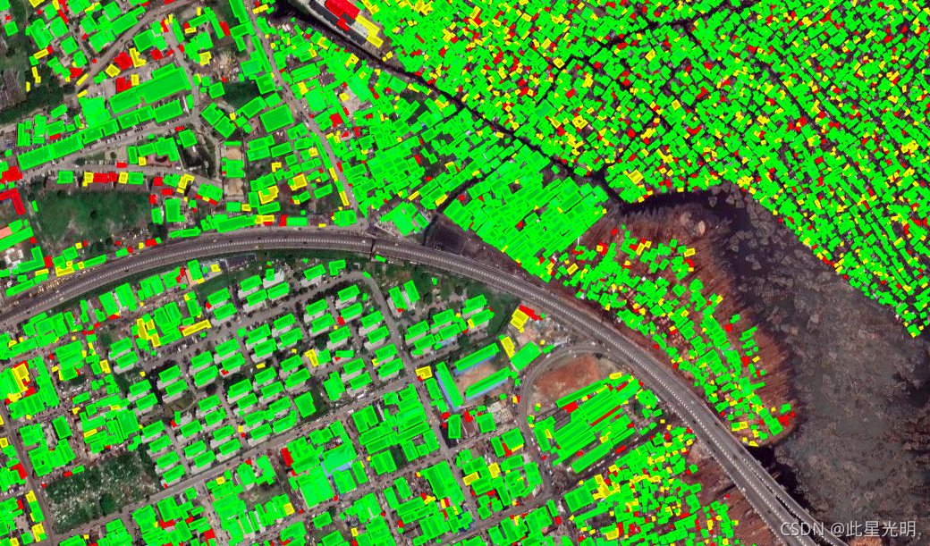
Google Earth Engine(GEE)——利用归一化建筑指数NDBI(不透水层)提取建筑物
问题:有粉丝问到,如何进行建筑物的提取,其实这里有两个方法,一个是有一个数据集可以直接获取建筑物的轮廓,具体内容可以看我之前的文章:(2条消息) Google Earth Engine ——高分辨率 50 厘米卫星图像的建筑物轮廓数据集_此星光明的博客-CSDN博客归一化建筑指数:NDBI是查勇等在杨山提出的仿归一化植被指数基础上提出的, 它可以较为准确地反映建筑用地信息, 数值越大表明建筑用地....
Google Earth Engine—美国西部11个州的灌溉状况进行的年度分类(即30米),1986年至今。四个等级的分类(即灌溉、旱地、非耕地、湿地)
IrrMapper is an annual classification of irrigation status in the 11 Western United States made at Landsat scale (i.e., 30 m) using the Random Forest algorithm, covering years 1986 - present. While t....

Google Earth Engine——Murray全球潮间带变化数据集在潮滩分类,用于开发陆地卫星协变量层的陆地卫星图像的数量
The Murray Global Intertidal Change Dataset contains global maps of tidal flat ecosystems produced via a supervised classification of 707,528 Landsat Archive images. Each pixel was classified into ti....

Google Earth Engine——BigEarthNet是一个新的耕地Sentinel-2数据,由590,326个Sentinel-2图像斑块组成的土地覆盖高清数据集
BigEarthNet is a new large-scale Sentinel-2 benchmark archive, consisting of 590,326 Sentinel-2 image patches. To construct BigEarthNet, 125 Sentinel-2 tiles acquired between June 2017 and May 2018 o....

Google Earth Engine——Arctic北极DEM是一个数字表面模型(DSM),描绘了包括植被、树冠、建筑物和其他人造表面特征在内的第一回的高程值,2米/5米分辨率
ArcticDEM is a digital surface model (DSM) that portrays first-return elevation values that include vegetation, tree canopy, buildings, and other man-made surface features. The 2m asset is a collecti....

Google Earth Engine——TRMM/34B2产品包含一个网格化的、经TRMM调整的、合并的红外降水(毫米/小时)和降水误差的有效值估计,时间分辨率为3小时,空间分辨率为0.25度。
The Tropical Rainfall Measuring Mission (TRMM) is a joint mission between NASA and the Japan Aerospace Exploration Agency (JAXA) designed to monitor and study tropical rainfall. The 34B2 product cont....

Google Earth Engine——美国人口普查局的TIGER数据集包含美国各州主要法律部门的2018年边界。在大多数州,这些实体被称为 “县“。在路易斯安那州,这些州被称为 “教区“。
The United States Census Bureau TIGER dataset contains the 2018 boundaries for primary legal divisions of US states. In most states, these entities are termed "counties". In Louisiana, these division....

本页面内关键词为智能算法引擎基于机器学习所生成,如有任何问题,可在页面下方点击"联系我们"与我们沟通。
google engine相关内容
- google earth engine栅格
- google engine数据
- google earth engine下载
- google engine应用
- google engine模型
- google engine构建
- google engine生物量
- google earth engine遥感
- google engine地上
- google engine雷达数据
- google engine空气
- google earth engine地表温度
- google earth engine gee卫星数据
- google earth engine森林序列
- google engine雷达
- google engine气候数据
- google earth engine导出
- google engine导出
- google engine空间
- google earth engine values
- google engine gee火灾
- google engine组织
- google earth engine gee landsat
- google engine landsat8 ndvi
- google earth engine gee landsat8影像
- google engine ndvi
- google earth engine evi
- google engine特征
- google engine gee特征
- google engine计算
google更多engine相关
- google earth engine lst
- google earth engine地图
- google engine gee案例
- google earth engine地表
- google engine面积
- google earth engine影像
- google earth engine融合
- google engine地球
- google engine gee
- google earth engine gee contain
- google earth engine数据集
- google engine分辨率
- google engine影像
- google engine gee数据集
- google earth engine数据数据集
- google engine modis
- google earth engine图像
- google earth engine指数数据集
- google engine数据集分辨率
- google engine植被
- google engine分辨率数据集
- google earth engine土壤
- google earth engine global
- google engine数据集数据
- google earth engine归一化
- google engine dem
- google earth engine人口
- google engine分类
- google earth engine面积
- google earth engine陆地
google您可能感兴趣
- google代码
- google视频
- google python
- google架构
- google实战
- google模型
- google工具
- google搜索功能
- google策略
- google推理
- google earth
- google数据集
- google gee
- google数据
- google play
- google分辨率
- google chrome
- google应用
- google解析
- google开源
- google搜索
- google影像
- google ai
- google浏览器
- google分析
- google谷歌
- google网站
- google guava
- google地图
- google landsat